← Home · Seismic

Seismic Microzonation Studies in Chicago: A Practical Engineering View

Together, we solve the challenges of tomorrow.

LEARN MORE →

In Chicago, seismic risk is often underestimated because of the distance from active plate boundaries. We see this in the field: engineers apply generic site class D without checking the deep glacial till and soft lacustrine clay layers that dominate the Lake Michigan shoreline. These deposits control site amplification. A proper seismic microzonation study maps the transition from stiff silty clay to loose sand at depth. The work relies on correlating CPT testing results with MASW surveys to measure Vs30 across the site. We then build a ground model that reflects the local Pleistocene stratigraphy, which is far from uniform in the Chicago area.

Flat topography does not mean uniform seismic response. Chicago's glacial lake clays amplify long-period ground motion in ways that a generic site class D cannot capture.

Methodology and scope

The most common mistake we encounter is assuming uniform soil conditions across a site simply because the surface is flat. Chicago's geology is a complex sequence of glacial tills, outwash, and lake plain deposits. An incorrect site class leads to an overestimated or underestimated base shear in the structural design. Our microzonation approach starts with high-density geophysical lines. We calibrate shear wave velocity profiles with seismic refraction and SPT drilling data. We then generate maps of spectral acceleration at the surface, accounting for 1D site response. The output is not just a Vs30 map; it is a grid of amplification factors and site periods tied directly to the IBC Chapter 16 ground motion parameters.
Seismic Microzonation Studies in Chicago: A Practical Engineering View
Technical reference image — Chicago

Local considerations

The Great Lakes tectonic setting creates a specific risk profile. Chicago is subject to long-period shaking from distant New Madrid and Wabash Valley seismic zones. The soft organic silts and clays along the Chicago River and Calumet corridors are prone to amplification at 1-2 second periods. This matches the natural period of 10- to 20-story buildings. A microzonation study identifies these resonance zones. Without it, a structural engineer may design a moment frame that aligns perfectly with the site period, increasing drift demands beyond code limits. We map these period lengthening effects block by block, integrating the local water table depth and the thickness of the compressible Blodgett unit.

Need a geotechnical assessment?

Reply within 24h.

Email: contact@geotechnicalengineering1.org

Technical parameters

ParameterTypical value
Minimum Vs30 Mapping Resolution30 m grid spacing
Max Investigation Depth30 m (100 ft) per site class D/E
Primary Geophysical MethodMASW + ReMi combination
Site Class Range in ChicagoC (stiff till) to E (soft clay)
Reference Ground MotionASCE 7-22 Chapter 11 MCE
Amplification Factor Range0.8 - 2.4 (0.2s spectral)
Data Output FormatCSV, SHP, DXF, GeoJSON

Associated technical services

01

Vs30 Mapping and Site Classification

Grid-based shear wave velocity profiling using active-source MASW calibrated with CPT and SPT borings to define site class boundaries per ASCE 7-22.

02

1D Site Response Analysis

Equivalent-linear ground response modeling (DEEPSOIL) using Chicago-specific input motions and dynamic soil properties from resonant column and cyclic triaxial tests.

03

Liquefaction Triggering Maps

Assessment of fine-grained soil sensitivity in near-lake fills, using SPT-based cyclic stress ratio calculations and site-specific peak ground acceleration.

04

Design Ground Motion Reports

Site-specific response spectra and acceleration time histories for structural analysis, including long-period transition effects relevant to tall buildings in the Loop.

Applicable standards

ASCE 7-22 Chapter 20: Site Classification Procedure, IBC 2021 Section 1613: Earthquake Loads, ASTM D4428/D4428M: Crosshole Seismic Testing, ASTM D7400: Downhole Seismic Testing, NEHRP Provisions Part 3: Site Response Analysis

Frequently asked questions

What is the cost of a seismic microzonation study in Chicago?

The price range for a site-specific study in the Chicago area is between US$4,580 and US$19,300. The variation depends on site size, number of geophysical lines, and whether 1D or 2D response analysis is required.

Why is microzonation needed if Chicago is not in a high-seismicity zone?

Chicago's deep soft clay deposits amplify long-period motion from distant sources. A site class D default can misrepresent acceleration for tall structures. Microzonation provides the correct site factors for the structural design.

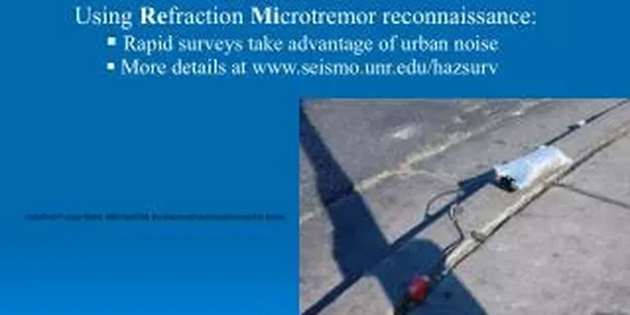
Which geophysical methods do you use for Chicago geology?

We combine active MASW with ReMi for deeper profiling. The results are calibrated with downhole seismic in SPT borings. This hybrid approach works well in the layered glacial till and outwash of the Chicago area.

How does the microzonation report integrate with IBC requirements?

The report provides mapped site classes and site coefficients Fa and Fv per ASCE 7-22 Tables 20.3-1 and 20.3-2. It also includes the design response spectrum adjusted for site effects, ready for structural input.

What is the typical investigation depth for a Chicago microzonation?

We typically investigate to 30 meters (100 feet) for site classification. For tall buildings with deep foundations, we extend the Vs profile to 60 meters using ReMi and downhole methods to capture the full soil column response.

Location and service area

We serve projects across Chicago and its metropolitan area.

View larger map