Chicago sits at an average elevation of 597 feet above sea level, resting on a sequence of glacial till, lacustrine clays, and occasional sand lenses deposited by Lake Michigan's ancestral shorelines. The 2008 Mt. Carmel earthquake, though moderate at M5.2, reminded structural engineers that the Midwest craton is not aseismic. For any structure over three stories in the Loop or a critical facility in the suburbs, ASCE 7-22 mandates a VS30 measurement to assign the correct site class. We run active-source MASW surveys along 46- or 69-meter spreads, picking fundamental-mode Rayleigh wave dispersion curves to invert shear wave velocity profiles down to 30 meters. The result feeds directly into Chapter 20 of ASCE 7, replacing default site coefficients with measured data that can shrink the design spectral acceleration by 15 to 20 percent on stiff Lake Border till, compared to the overly conservative Site Class D assumption. When borehole control is available nearby, we cross-check the inverted VS profile with SPT N-values, and for deeper bedrock mapping we sometimes combine the survey with a seismic refraction line along the same alignment.
A measured VS30 of 420 m/s on Lake Border till can shift a Chicago mid-rise from Site Class D to C, cutting base shear demand by nearly 20 percent.
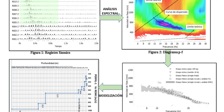
Methodology and scope
The most common mistake we see in Chicago is running a single downhole PS-suspension log in a borehole and calling it a day, then missing a lateral velocity reversal between two boreholes that the IBC requires to be captured. MASW fills that gap. A 2D surface array picks up the fundamental mode across the entire spread, so a low-velocity lens of organic silt buried under 8 feet of fill—common along the old channel of the South Branch of the Chicago River—appears as a clear dispersion anomaly. We process the raw shot gathers in the frequency-phase velocity domain, identify the fundamental mode between 5 and 45 Hz, and invert with a damped least-squares algorithm that honors the stiff clay half-space typical of the Valparaiso moraine. The final VS30 value is never just an average; we report the coefficient of variation across the array and flag any segment where the velocity contrast exceeds 2:1, because that is where differential settlement will concentrate under seismic cyclic loading.
Local considerations
Post-Fire Chicago rebuilt fast, filling the lakefront with debris from the 1871 blaze and later with dredged sand to create Grant Park and the shoreline we know today. That artificial fill, often 10 to 15 feet thick over the original marsh, has never been dynamically compacted by anything stronger than the 1909 Aurora earthquake. A MASW survey across a site on Streeterville fill routinely shows VS values below 180 m/s in the upper 6 meters, classifying the site as Class E or F depending on the thickness of the fill. Below the fill, the soft Chicago Clay exhibits a shear wave velocity increase from 150 to 280 m/s with depth, matching the consolidation profile. Without a measured VS30, the structural engineer defaults to Site Class D, which under-represents the amplification at short periods and can lead to non-ductile inter-story drift in concrete frame buildings. We have mapped velocity contrasts along Michigan Avenue where the fill-clay interface dips 12 percent toward the lake, a geometry that traps seismic energy and amplifies peak ground acceleration by a factor of 1.4 according to 2D site response analyses we performed for a hospital retrofit project.
Frequently asked questions
How much does a MASW VS30 survey cost for a typical Chicago lot?
For a single 69-meter array with one shot location, the cost ranges from US$1,660 to US$3,590 depending on site access, traffic control requirements, and whether we need to correlate the profile with existing borehole data. Sites in the Loop that require night work and lane closures fall at the upper end of that range.
Can MASW penetrate the hard dolomite bedrock beneath Chicago?
Active-source MASW with a sledgehammer reliably resolves shear wave velocity down to 30 meters in the glacial drift, but it does not generate enough low-frequency energy to characterize the top of the Silurian dolomite if it is deeper than 45 meters. For deeper bedrock mapping, we pair the MASW with a seismic refraction line or, when the site is accessible, a microtremor array measurement (MAM) using passive-source techniques.
Does a MASW survey replace a borehole for IBC site classification?
No. The IBC and ASCE 7 accept VS30 from surface geophysics as the primary site-class parameter, but you still need at least one borehole to confirm the lithology and check for problematic layers like peat or loose sand that the velocity alone may not identify. Our standard deliverable includes a site class letter that references both the MASW VS30 and the nearest IDOT or private boring log.